Showing posts with label water flow. Show all posts

Tuesday, November 5, 2013

Flow Day!

November 05, 2013 0

Mike Bush is a guest blogger and a PhD student in the Trexler aquatic ecology lab at FIU (http://faculty.fiu.edu/~trexlerj/).
 -------------------------------------------------------------------------------------------------------------

                Everglades restoration can come in many forms, from ensuring that water heading south through the Everglades Agricultural Area is stripped of excess nutrients before it hits the more natural areas of the Everglades to shuffling around huge amounts of water under Alligator Alley into Fakahatchee Strand.
Perhaps no project is as ambitious as the Water Conservation Area 3A Decompartmentalization and Sheetflow Enhancement Project (we just refer to it as “DPM” or “Decomp” for short, thank goodness). DPM is a multifaceted project, with major involvement by the South Florida Water Management District and the US Army Corps of Engineers, that focuses on removing levees and plugging canals that are found throughout the Everglades, hence the “decompartmentalize” part. The overarching goal here is to restore sheetflow, that slow moving conveyance of water through the Everglades that inspired Marjory Stoneman Douglas’ phrase “River of Grass”. A component of DPM is the DPM Physical Model, the first step in testing how restoration of sheetflow will affect sediment and nutrient transport. This in turn could affect the plants and animals of the system, including how the ridge-and-slow structure of the Everglades is maintained or altered.

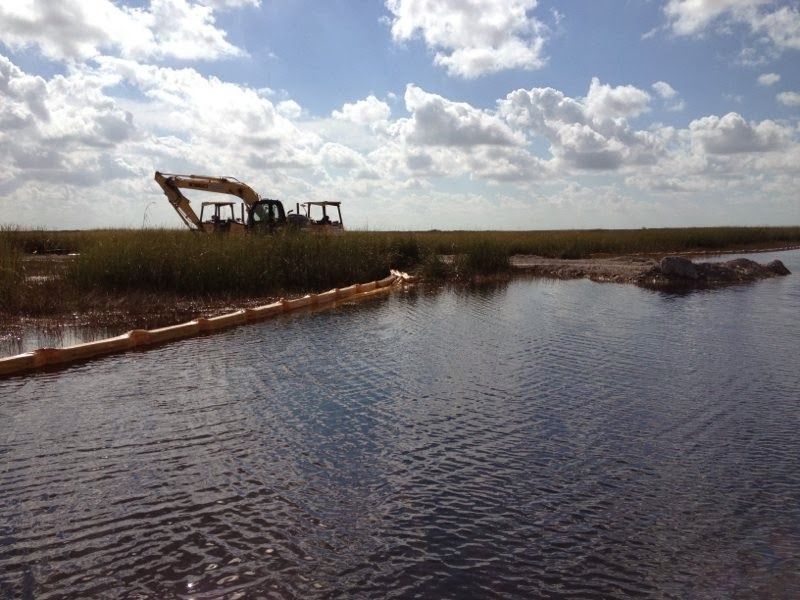
                Construction for the project about a year ago, and the lab I’m in has been collecting fish, amphibian, and aquatic invertebrate data since Fall 2010. Water is projected to flow east from a section of the Everglades known as Water Conservation Area 3A, through a series of culverts in the L67-A levee, across a roughly 1 mile section of marsh known as the “Gap” or “Pocket”, and then across the L67-C canal and levee into Water Conservation Area 3B. The C canal, where many of my field sites are, has either been filled in entirely or partially filled across the experimental zone. This will examine whether future restoration projects can get away with just partial canal fills, a much cheaper option than filling a deep canal with earth all the way to marsh level. The project is finally complete and today the culverts in the A levee were opened. Today, known to many in many agencies and institutions as “Flow Day”, is the first day in what hopes to be a great day for Everglades restoration.  I am amazed at how much manpower and collaboration goes in to trying to restore natural components of the Everglades landscape. And it’s certainly odd to spend so much time out here with no other humans (besides some very dedicated and excellent field technicians), and suddenly there’s a fleet of dump trucks and earth movers out in the middle of the Everglades! Well worth the effort though for this exciting (and necessary) project for restoration.
                I’ll post aerial photos within the next couple of weeks! Stay tuned! Photo credits go to Sabrina Schneider, one of those very excellent techs I spoke of.


Tuesday, September 4, 2012

Leaky Levees

September 04, 2012 0

Our regular bloggers are out gathering data so today we have a guest blogger, Stephanie Long from the Department of Earth and Environment. 
----------------------------------------------------------------------------------------------------------------------------------------

Despite all of the extreme weather reporting and constant television coverage, Hurricane Isaac was just another storm for most of South Floridians. The only trouble the storm brought us was copious amounts of rain. So when I got a chance to go take samples along the L30 Levee just three days after the storm had passed, I was given a very fundamental lesson in South Florida hydrogeology.

Fast moving water coming through 
the L30 Levee and into the L30 Canal.
Water Conservation Area 3B is FIU's nearest WCA neighbor. It is bordered by the Tamiami Canal to the south and the L30 Canal to the east. Three days after Isaac, the water in WCA 3B was pretty high; it even seemed to swamp the invasive cattail. We drove northeast along the L30 levee and got out south of control structure S-335 to collect a grab sample. The sound of trickling water was odd. There is close to zero elevation gradient everywhere in South Florida, we don't get a lot of trickling streams. What is this sound?


 Here I'm on top of the Levee and you can see the Miccosukee Casino in the background.

The L30 Levee typically holds water back into the conservation area, allowing it to seep into the groundwater and recharge the aquifer, or else seep into the canal and provide water for the agricultural areas to the south. Understanding the flux of water through and under the levee is important for water budget estimates and managing flows. These images show just how porous the levee really is and, as a researcher from the Park pointed out that day, it may serve as a confirmation that the number we see on our spreadsheets and in our models might be right. Next time you calculate a transmissivity that looks way too high to be real, maybe it is.
 No seepage through this levee, 
 but what's happening underground?

Just south of the Tamiami Canal, a slurry wall was put in along the L31N Canal. The intention here was to stop some of the eastward seepage to maintain water levels and flows within the park. Only time and more investigation will tell if and how well this plan works.

- Stephanie Long
Ph.D. Student, FIU
slong001@fiu.edu

Monday, June 25, 2012

Field work blues

June 25, 2012 0

Tropical storm…… slow moving…….. heavy rain……. breezy……. Not the phrases you want to hear when you need to go deep into the Everglades and do a days worth of electrofishing before June ends.  Thanks to tropical storm Debby, I am going to have to sample in an orange tropical threat level! 

One valuable lesson that I have learned over the few years that I have been doing field work is that if you wait till the last minute to sample,  super natural forces will make sure that your crucial sampling is impossible to finish.  Either something that you can’t fix will break, some plague will sweep through  your  lab making everyone too sick to help, or a tropical storm will park itself over south Florida.

The weather report however does look less bad tomorrow. So we are going out! wooO!   Because of all this rain, freshwater will be racing off upstream marshes and pouring into the estuary, which maybe something that snook prefer.  Fast moving water might dislodge prey from their hiding spots, flushing them into the main channels, making them easy prey for a hungry snook waiting at ambush sites. 

In the Peace river in South Florida, snook abundance and body condition (similar to a Body Mass Index) is very tightly and positively linked water flow into the rivers and inundation of surrounding floodplains. A few years ago at the end of a particularly rainy wet season, the snook in the peace river got so fat that anglers thought they were catching a new snook species they called the humpback snook! These snook look something like this!


 So hopefully we can find some snook tomorrow with full bellies!